دانستنیهای GIS و سنجش از دور (RS) و دانلود نرم افزارهای مرتبط
معرفی ، آموزش، اخبار و مطالب مهم در خصوص GIS و دانلود نرم افزارهای مرتبط با آندانستنیهای GIS و سنجش از دور (RS) و دانلود نرم افزارهای مرتبط
معرفی ، آموزش، اخبار و مطالب مهم در خصوص GIS و دانلود نرم افزارهای مرتبط با آندرباره من
 محمود شمس : * مدیر پروژه طراح و برنامه نویس سیستمهای SDI , WEBGIS ، GIS، ُمدیریت شهری ، مدیریت بحران و حوادث ، مکانیزاسیون و ...
* طراحی و پیاده سازی بیش از 50 پروژه GISی و مدیریتی برای تاسیسات پتروشیمی، پالایشگاه، پایانه های نفتی، بنادر، شبکه توزیع برق ، آب ، گاز ، مخابرات ، شهرداری ها و غیره.
*مدیر شرکت مکان پردازان آریان (MAPRUN)
* شماره تماس 09122630488
* ایمیل Shamsgis@gmail.com
ادامه...
محمود شمس : * مدیر پروژه طراح و برنامه نویس سیستمهای SDI , WEBGIS ، GIS، ُمدیریت شهری ، مدیریت بحران و حوادث ، مکانیزاسیون و ...
* طراحی و پیاده سازی بیش از 50 پروژه GISی و مدیریتی برای تاسیسات پتروشیمی، پالایشگاه، پایانه های نفتی، بنادر، شبکه توزیع برق ، آب ، گاز ، مخابرات ، شهرداری ها و غیره.
*مدیر شرکت مکان پردازان آریان (MAPRUN)
* شماره تماس 09122630488
* ایمیل Shamsgis@gmail.com
ادامه...
Mobile GIS technology update
Mobile GIS technology update
IntroductionThe way we work and play is being continually reshaped by technological development. This is especially true in Asia where the mobile revolution has driven trends in modern urban culture. Being able to communicate with anyone, anywhere, any time is now taken for granted, for example in Singapore 85% of people own a mobile phone and many use Short Message Services (SMS)1. With mobile communications, we are more adaptive and flexible as we go about the business of our everyday lives. In Hong Kong 72% of businesses now use mobile phones for more than just voice calls2 as wireless Internet and transfer of data using mobile phones increases.
http://www.gisdevelopment.net/technology/mobilemapping/ma04160.htm : منبع
While technology changes how we behave, the fast rate of urban and infrastructure development in Asia means that our landscape is also constantly changing. The roading and infrastructure in Beijing, for example, is being transformed in preparation for the 2008 Olympic Games.
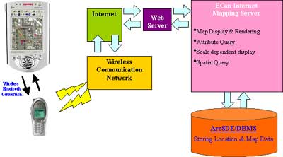
GIS databases, used by government agencies and private organisations, must keep up with this changing world to ensure best management of development and resources. Fortunately for the industry, recent advancements in Mobile GIS technology mean that it is possible to cost effectively collect, manage and use GIS data. Mobile GIS and GIS Data Collection
Mobile GIS is the accessing, using, and maintaining of geospatial data directly in the field. Mobile GIS addresses the needs not only of GIS managers, but also of field inspectors, maintenance teams, utility crews, emergency repair workers, and other field workers who require timely access to GIS data in the field. Field crews with access to enterprise GIS data can better target their actions with the latest information, and they are perfectly positioned to maintain the GIS database as they maintain physical assets.
Mobile GIS is made possible with developments in;
- Global Positioning System (GPS) technology
- Rugged handheld computing technologies
- Wireless communications
- GIS software for mobile platforms
Mobile GIS relies on having high quality data in the GIS database. However, in many organisations this data can be out-dated or even non-existent. Typically the only means to getting the accurate information required is to collect it yourself. GIS data collection is the process of populating a GIS with data on the features, including position and attribute information, of interest to the organisation. Methods to do this range from manually entering coordinates transcribed from pen and paper, to digitising aerial photographs or paper plans, to GPS data collection.
A GPS data collection system has the same basic components as a Mobile GIS system. It requires the user to be able to locate and then record position and attribute information about the features of interest. GPS technology provides the obvious choice for recording reliable position information, while handheld computer platforms running field-optimised software allow the user to efficiently record feature and attribute data. GIS data collection and Mobile GIS are intrinsically linked, firstly because they have similar technology requirements, but more importantly because the data generated by the former is critical to the latter. As a result, many organisations are choosing to deploy data collection systems that can expand to meet their Mobile GIS needs or Mobile GIS solutions that also provide GIS data collection capabilities.
GPS and Mobile GISGPS is now a standard and widely accepted method of providing position information for a wide variety of user applications, including Mobile GIS. In some locations GPS is the only effective way to map assets in the field. In Japan, for example, GPS-based systems have been used to quickly and accurately define private versus public forestry lands in difficult terrain with few landmarks. The use of GPS in this application allowed the user to achieve the level of accuracy required for the project, within their cost constraints.
جهت توضیحات بیشتر به این سایت رجوع شود .


